
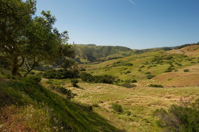
I promised myself that we’d climb a Flatiron peak before leaving Colorado this time around, but I wanted those valley views of the Flatirons; to approach the peak from a distance and then climb its sharp ledges. So the day before leaving Colorado, Ollie and I set out to summit Bear Peak beginning from the Foothills Highway (Route 93) and walking three miles across meadows and fields on the valley floor approach to the Flatirons. The views were fantastic the whole way! The roundtrip distance totaled 13 miles so I took my time and it took most of the day. A Brat Burger and Butcherknife Bavarian Hefeweizen at Euclid Hall right afterward was the perfect fix after a day of hiking through field, forest and mountain.

The Summit of Bear Peak – Boulder, CO
We left the deep canyons of Colorado early on a Tuesday morning and took I-70 West straight across the rest of the state, passing through snowstorm after rainstorm after hailstorm and ice-covered highway. Sometimes we sat in traffic completely still for what seemed endless time. It wasn’t until we crossed the Continental Divide that things changed. The elevation dropped and the temperature rose; everything shifted, the snow receded and what was uncovered was dry gravel and grass.

Canyonlands
We took a break at the Colorado National Monument, exploring the canyons, caverns and rim rocks that wove a thousand tails as we meandered for miles.


We reached this fantastic rock, Independence Monument, a tall prominence that stood straight up in a deep and flat valley and all I could think was wow, can you imagine climbing that? It would be awesome!!

Beautiful canyon landscape with some interesting sandstone formations.
It turned out the tourist kiosk had information about the climb that a small number of people take each year up the tall edifice. As I was staring at the rock, my eyes started to depict movement…but I wasn’t quite sure. It looked like there were rock climbers on the rock. I took out my zoom lens to be sure and snapped a few close up photos, and lo and behold, there were rock climbers right below the summit, negotiating their way to the top!

Driving through Arizona
When we left the national monument, we made a short stop to bid farewell to the winding Colorado River and it was less than 20 minutes before we reached Utah. We drove straight across Utah, stopping only once, in Moab, for an unfortunate bite to eat. I was expecting more from Moab, but I guess I’d need to have spent more time to make a fair judgement. Once we hit Utah, canopies of trees no longer existed — only brown, dry, cracked land for miles and miles and miles. We raced south straight down Route 191 to Route 163 for Mexican Hat and it was by virtue of speeding that we made it to the Monument Valley overlook just by the end of sunset.

Western Dream Sunset, Monument Valley
As the sun went down, the monuments and mesas of Arizona rose in the distance with a purple and gold hue from the last of the day’s light. We continued toward the tall sandstone peaks, passing through a land of giants as darkness fell; and once we got to Arizona, we found ourselves immediately on the Navajo Nation Indian Reservation. I couldn’t believe people lived here, the landscape was so dry and empty, and the communities seemed more like ghost towns.

Mesa
I didn’t want to believe that small, sweet children lived here, that older people who need help getting around lived here; that ANYONE lived here, in this desolate corner of Arizona. There were no streams, no canyons, no administration buildings, or town meeting halls, just ramshackle shacks. Like the Native Americans had been forced to leave luscious forest and forced to live in a forgotten abyss with barely any resources. My heart cried out for them, cried out for any person who is forced to live this way. And we hadn’t even gotten to the home of the infamous “Tent City,” and already we were seeing the societal decay that comes with ostracizing, mistreating and manipulating an entire group of people.

Red Rock Canyon
Before this I had some fantastical idea about Indian Reservations, but this struck me back to reality. By the time we crossed through the Navajo Nation Reservation, the rest of the drive took on a more somber tone. We drove through the Coconino National Forest through the night; next time, we’ll see the Grand Canyon — this time we passed it in a pitch black night.

View from our morning hike spot. (Vortex 1)
We woke up in Sedona, Arizona. The mountains were calling as soon as I woke, so Ollie and I hopped in the car and got lost, stumbling upon a hiking trail that looked like it lead somewhere neat. We climbed to the top of a large red rock and got an almost immediate 360 degree view of Sedona and its beloved red rock wilderness. The air was warm, and pink from a dying sunrise still lingered like a silk scarf across dramatically large, low-hanging clouds. Standing up there, looking over the world (or a small part of it, at least) I felt the sun pouring over me, with all its love and goodness. I meditated, with my right hand pup Ollie sitting next to me, as he took it all in with his sweet puppy smile.

Ollie at our morning hike spot.
I later found out from locals that the rock we were meandering and meditating on top of, was actually a vortex. When asked how I found it all I could say was that I had just been driving around and it just looked like someplace I wanted to explore. “Ah, you were called to it,” locals would reply. Ironic because I was walking around asking if anyone could tell me where I could find the vortexes. According to locals, the vortexes change you emotionally. They bring out to a greater extent, what’s already present inside of you. This can last anywhere from a few moments to a few months. Some people report feeling too much and have to leave the presence of the vortex, some people report their hair standing on end. That wasn’t my natural reaction but it felt special that the first place I had gone, that had “called to me,” was in fact a well-known vortex and just what I was looking for. It found me just as I found it. I can’t say I felt very different from meditating in, or walking around the vortexes. I fully admit, it was enlivening to be in the open outdoors in such a beautiful place, meditating on life, yes. But as for being soul cleansed by the vortex? I’ll have to return sometime and test the waters again.

Cathedral Rock (Vortex 2) / Yoga Spot in the Stream
Although, I was doing yoga in a stream facing Cathedral Rock (another well-known vortex) and as I was bending backward I felt a powerful sensation through my heart. I could say it was the effect of the vortex, or I could say it was the fact that I hadn’t engaged those muscles much lately and my body was opening because of the yoga, I wasn’t sure. I enjoy using both scientific fact and faith, and this event obviously lies somewhere in the
middle. After some great Mexican food paired with a delicious Prickly Pear Margarita (which to me just tasted like a regular margarita but was bright pink, yay!), we had a good night and left early the next morning, for our drive from Arizona straight to the California coast.

Ollie playing in the water below Cathedral Rock.
As we drove past Phoenix and caught I-10 West, the tall and succulent cacti I’ve only ever seen in westerns and cartoons, came into view. With arms outstretched and upward, they dotted the highway for two straight hours, and I couldn’t help but giggle — they were reminiscent of the Tin Man from Oz, before he was given the oil he needed to move; they had so much character. Many were taller than me! Though, that’s not difficult as I stand 5’3″ tall, haha. Leaving Arizona behind, we entered into California by noon, and continued through Joshua Tree and Palm Springs to Santa Monica, where we stopped for chai latte and an impromptu beach yoga sesh. We then continued up to Santa Barbara for fish tacos and spent the rest of the waning day driving up to San Luis Obispo. I still haven’t gotten much of a chance to explore SLO, so now since I’m living in California I’ll have to spend some time.


The very next day we jumped in the car and took a long journey through Big Sur heading north, navigating the backroads and dirt roads through canyon, stream, and mountainside.
Big Sur Backcountry
We had a dream-like lunch at Nepenthe, overlooking the corrugated golden coast mountains running into a chimerical blue ocean.

In a meadow o’er the sea…
We had our french fries stolen by beautiful bluebirds and sat in the shade of vibrantly colored umbrellas sipping wine and watching the day drift away. Eventually we continued our exploring, venturing onto Old Coast Road, slowly making our way up to Pacific Grove for the night.
-

- Sunset-Strolling in Pacific Grove, California
-
- Cypress and Sunset, Pacific Grove
There were doings at McWay Falls and the park rangers were out but it wasn’t clear why (until the next day). Once in Pacific Grove, we walked along the shores of Monterey Bay in the sunset as the magenta flowerbeds glowed in the evening shadows and the sun fell behind the coastal cypress trees.

Ah Bixby, how I love you.
The following day we undertook the journey south through Big Sur for a different perspective (and to catch all the spots we had to forgo because of time the day before). We explored the area around the Bixby Bridge, and continued on to Pfeiffer Beach where we ran along the purple-sand shores and sunk bare feet into earth and ocean. Pfeiffer Beach is so vast, I feel as if it’s a beach for giants. And Ollie loved it! After the beach, we headed over to McWay Falls and realized what yesterday’s commotion was about — some sweet, wonderful man had proposed by way of climbing down into the “closed area” and writing “Will U Marry Me?” in the sand of the beach under the waterfall! I hope he didn’t get in trouble, but either way it was quite romantic! We continued down the coast returning to Santa Barbara, to spend a few days enjoying the tranquil bliss of the “American Riviera,” but stopped at a few wineries along the way, just to mix things up. I’m a white wine person myself, but the deep red Syrah at Cerro Caliente was fantastic! I would have bought an entire case (had I had room in the car, haha).

Central Coast Vineyard
We continued beyond the fields of grapes and grandeur, and arrived back in Santa Barbara just in time to check-in and watch the sunset atop East Camino Cielo. After sunset I headed over to the Santa Barbara Airport to pick up my parents whom, by now had flown in to see California for themselves (though, I’m sure they really wanted to make sure I was still alive and in one piece), and I was elated to have the opportunity to show them around Santa Barbara and San Diego. I love them so much!
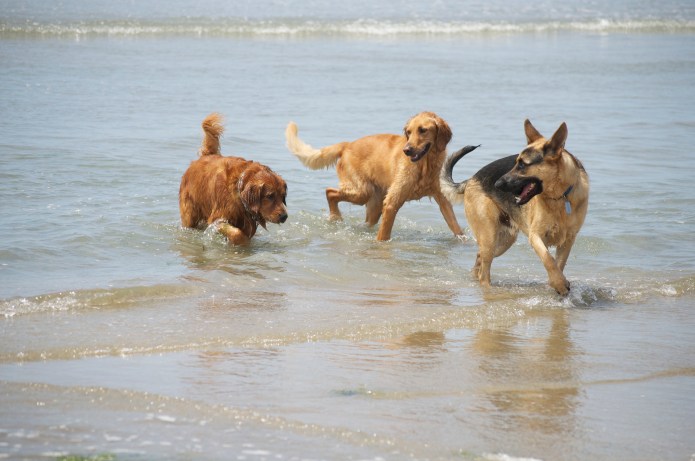
Dog Playdate – Ocean Beach Dog Beach, CA
After a few days of basking in the sweet Santa Barbara sun, taking time in beautiful courtyards and devouring fish tacos beachside, we headed down the coast for San Diego. It took a little over a week of Craigslist, PadMapper and visiting some hilariously sketchy spots, but I finally found an apartment just 8 minutes from the beach, with a deck surrounded in glorious green trees!

A Room with a Door


Whole Foods is literally around the corner and my favorite spot for chai lattes is around the other corner. When I look back on this nomadic journey across my beloved America, then return to my present state, sitting shrouded in trees on the deck, with the California sun dappling delicately through the leaves, I realize I didn’t get here by accident; I got here on purpose, I arrived here because I made it happen. Now onward and upward, there is much to do; the trees are green and the skies are blue! Time for a walk on the beach with my favorite orange Golden Retriever.

Swamis, our new home.


Recent Comments