
Home⎟Hikes & Wanderings⎟New York⎟Hudson Valley⎟Mount Beacon & Beacon Reservoir
Distance: 5.08 miles
Time: 3 hours 40 minutes
Difficulty: Moderately Strenuous
Elevation Gain: 1,600 feet


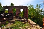
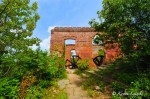
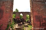
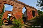


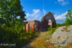


Once the steepest inclined railways in the world, Beacon’s incline railway ran from 1902 to 1978, eventually stopping operations due to insufficient funds. In 1927, both the Beaconcrest Hotel and Casino were destroyed by fire. The casino was rebuilt in 1928 but fell on hard times, along with the railway in the 1970’s.
Trailhead Directions: From the New York State Thruway heading North, take exit 17 to Interstate-84 East. Continue on I-84 for about 5 miles, and take exit 11 for Rt. 9D directly beyond the tollbooth. Turn RIGHT onto Rt 9D South for 2.6 miles to the Mt Beacon Trailhead parking on your LEFT.
Nearest Address: 777 Wolcott Avenue Beacon, NY
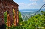
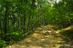
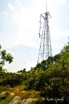
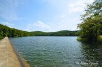
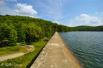
Hike Directions: Follow the gravel road from the parking area 0.17 miles to an open area with parts of the original inclined railway still visible. From here, take the RED-BLAZED Casino Trail, ascending Mount Beacon via switchbacks. After 0.28 miles on the Casino Trail, you’ll see a path continuing beyond a switchback. It descends the mountain for a few hundred feet to a deck overlooking the original incline railway. The views afforded here are small compared to what lies ahead. ![]() Continue up the Casino Trail for a little over half a mile to the outcropping where the Beaconcrest Hotel, Casino and Powerhouse once stood. Now all that is left standing is the powerhouse and an overlook so expansive, on a clear day the Catskill mountains are Shawangunk cliffs are visible in the distance. From here, continue to follow the RED BLAZES beyond the outcropping, and start to steadily ascend the mountain toward the fire tower. 0.32 miles beyond the ruins, you’ll come to an open intersection with a number of unmarked paths – go LEFT here, departing from the red blazes onto an unmarked path. Follow this wide and well-maintained path as it first ascends the hill. In just a tenth of a mile you’ll reach an intersection where the communications towers are visible – turn AWAY from the communications towers to continue following the unmarked road for another 0.4 miles as it heads downhill to the Beacon Reservoir. At the Beacon Reservoir hang a LEFT and cross the dam, as you begin to circumnavigate the reservoir.
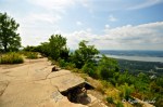
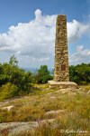
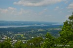
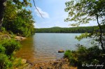
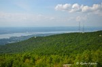
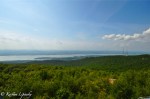
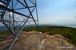
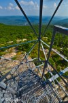
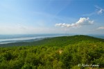
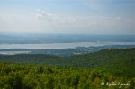
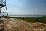
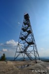
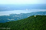
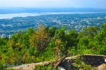
Continue up the Casino Trail for a little over half a mile to the outcropping where the Beaconcrest Hotel, Casino and Powerhouse once stood. Now all that is left standing is the powerhouse and an overlook so expansive, on a clear day the Catskill mountains are Shawangunk cliffs are visible in the distance. From here, continue to follow the RED BLAZES beyond the outcropping, and start to steadily ascend the mountain toward the fire tower. 0.32 miles beyond the ruins, you’ll come to an open intersection with a number of unmarked paths – go LEFT here, departing from the red blazes onto an unmarked path. Follow this wide and well-maintained path as it first ascends the hill. In just a tenth of a mile you’ll reach an intersection where the communications towers are visible – turn AWAY from the communications towers to continue following the unmarked road for another 0.4 miles as it heads downhill to the Beacon Reservoir. At the Beacon Reservoir hang a LEFT and cross the dam, as you begin to circumnavigate the reservoir.  The shores of the Beacon Reservoir are dotted with perfect coves and hidden spots where you’ll find locals and tourists alike sunning themselves, swimming or generally lazing any beautiful summer day away. The unmarked path is obvious as you make your way around the Eastern side of the reservoir for 0.42 miles and then depart from it, heading uphill for another quarter mile, soon meeting up with the Casino Trail’s RED BLAZES. Turn RIGHT onto the Casino Trail and follow for just 250 feet before turning LEFT and ascending an obvious but unmarked path (well, maybe a little marked by locals) for just 0.2 miles to the fire tower.From here it feels as though the entire Hudson Valley is visible, but you’re really just seeing a large part of it. In the distance the catkills and shawangunks loom; Schunnemunk Mountain, Dennings Point and Newburgh are visible looking west, while Beacon and the Newburgh-Beacon Bridge can be seen just north. The top of Storm King as well as the backside of Breakneck Ridge and Mount Taurus are also visible. After enjoying the views, descend on the same unmarked path, and turn RIGHT onto the RED BLAZED Casino Trail and in 0.77 miles you’ll reach the Casino ruins once again. Keep to the RED-BLAZES as you descend the mountain, back to Mount Beacon Park and your car.
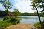
Scenery: 8/10

2 replies »