
Home⎟Hikes & Wanderings ⎟ California ⎟Ho Chi Minh Trail
The Ho Chi Minh abuts Torrey Pines Preserve’s southern border and begins at the end of Salk Insitute Road. I parked at the Torrey Pines Gliderport since it made it easy to cross through the Salk Institute and find the trailhead.
Distance: 1.5 miles
Time: 1 hour
Difficulty: Moderate (with a few challenging sandstone scrambles involved)
Elevation Gain: 350 feet
Dog Friendly: Yes. Before 9am and after 6pm (except in winter when dog exempt time switches to 9am-4pm).
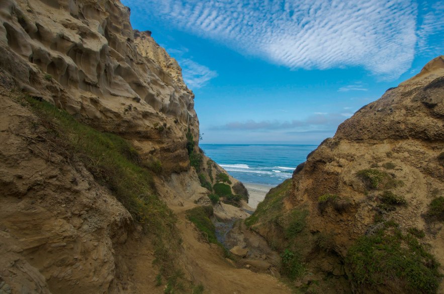
Trail Notes: This hike is best done barefoot (preferred) or in shoes with good traction as the sandstone can be loose and/or slippery. I always do this barefoot, but bring shoes just in case. I’d also avoid this route after a rain, as the sandstone can easily break apart causing possible injury. This trail is mostly used by surfers and extreme hiker locals, and is a whole lot of fun! Not only are the views spectacular all the way down the canyon, but the trail ends at Black’s Beach, an expansive surfers’ beach known for its amazing waves. Anytime of day, it’s easy to turn Black’s into your own private hideaway and find a little piece of paradise all to yourself. Walk to its southern end and you’ll find the famed Mushroom Beach; keep going and you’ll eventually reach Scripps Pier and La Jolla Shores Beach. Walking to the northern end of Black’s, you’ll eventually find yourself at the iconic Flat Rock of Torrey Pines State Beach, where you can create numerous spur hikes to the top of the cliffs or even make an excursion into the bustling beach city of Del Mar, CA.
Trailhead Directions: Take the I-5 to Genesee Avenue and at the top of the ramp, go left if you’re coming from the south, right if you’re coming from the north. Take your first left onto North Torrey Pines Road and continue 0.4 miles to then make a right on Torrey Pines Scenic Drive. Continue to the parking lot at the end of the road.
Hike Directions: Exit the Torrey Pines Gliderport parking area and walk up Torrey Pines Scenic Drive to make your first right onto a pedestrian walkway that crosses through the Salk Institute for Biological Sciences. Once you reach Salk Institute Road, make a right and walk to the end of the road. The trail begins here. Leave the road and continue straight, heading down the hill on a narrow and sandy path. The trail curves left as you descend. Soon you’ll reach a grove of trees and brush, along with a plank to cross a small stream area. Cross the plank or forge the stream, but either way continue straight. Only a minute after crossing the plank, you’ll meet with gorgeous views of the ravine running downhill into the Pacific Ocean. The trail enters a narrow crack. Descend carefully on the sandstone here, as it is easy to slip and fall. Ollie and I stayed to the left of the ravine as we descended, as there was more room for good footing. At the bottom of the narrow crack is what resembles a roofless room. It feels as if your in a scooped out cave with no ceiling, which is pretty amazing! After taking a moment here for some good photo ops, continue down the ravine for a few hundred more feet before reaching a lush green area with a rope against rocks. While it’s possible to get up and down without the rope, the area is even more slippery than it looks, so I’d recommend making use of it. The descension on the rope is just barely 15 feet before you reach the beach. Paradiso Trovato! Return the way you came.
Scenery: 10/10.


You must be logged in to post a comment.