Home ⎜ Hikes & Wanderings ⎜ New York ⎜ Adirondacks ⎜ Tongue Mtn Range
Distance: 13 miles
Time: 7-8 hours, but take the day and enjoy!
Elevation Gain: 3,400′
Difficulty: Strenuous
Dog Friendly: Yes!
Trail Notes: If you’re planning on leaving for this hike before dawn, see attached driving directions. Also, there is little to no cell phone reception along Route 9N in this section, and you’ll find very little atop the summits (though, the summits are your best bet in an emergency).
Trailhead Directions: From the New York State Thruway driving north, take exit 24 and bear right onto Bolton Landing-Riverbank Road. Continue 4.7 miles to then make a left on Route 9N North and in 4.4 miles you’ll arrive at a roadside parking area alongside a small quarry pond. The only road sign that indicates “Clay Meadows” is actually on the hiking trail itself, so don’t follow that signage per se because you’ll end up driving down the hiking trail (which would definitely require 4-wheel drive or a good friend to pull you out eventually). But the parking lot is just north of that sign. Just remember, if you don’t see a pond, it’s not a parking lot.
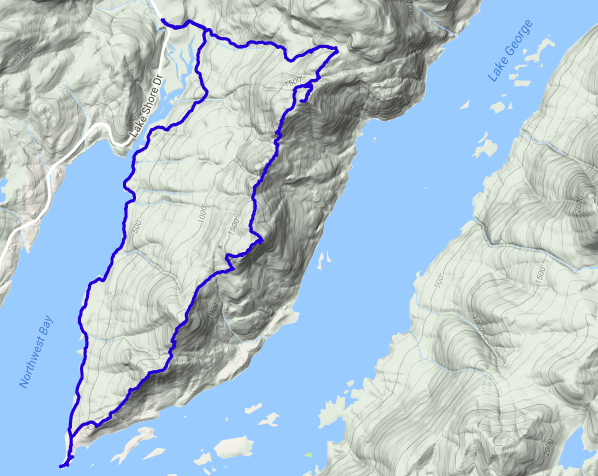
Hike Directions: From the parking area abutting the quarry pond, walk south on Route 9N for about 50 feet toward signage for “Clay Meadows.” Veer to the left of the sign and you’ll be on the trail. Continue into the forest, following blue trail markers for 0.2 miles to an intersection where you’ll continue straight/to the left as you begin to ascend Fifth Peak. Toward the summit, you’ll reach a small intersection with a yellow blazes spur trail. Take this to the lean-to on the summit of Fifth Peak, then backtrack to this spot. The lean-to has great (but limited) views over Lake George and French Point Mountain. From here, continue on the blue blazes as you cut across the backside of Fifth Peak’s summit (there are no views but forest here). You’ll soon find yourself losing elevation as you leave Fifth Peak, enter a col and begin your ascent up French Point Mountain. At the top of French Point, you’ll find much more expansive views than Fifth Peak, and French Point’s summit is a perfect break spot. Continue on the blue blazes as you leave French Point and climb First Peak. Both French Point and First Peak offer amazing views, but First Peak is a definite favorite. Enjoy its soft, grassy summit (watch for snakes!) and then continue on the blue blazes into yet another col and up yet another smaller peak. Continue along this trail of crests and troughs until finally arriving at Montcalm Point, the very tip of the Tongue Mountain Range. This piece of land actually used to separate two ancient rivers, that are now the one beautiful Lake George. This is a wonderful swim spot for dog and human alike, but be wary of the very strong current! From Montcalm Point backtrack along the trail to a fork in the road and take the left fork. It will lead you across the western shore of the range. The rest of the hike is mostly along quiet shoreline, with many swimming holes to stop and enjoy. Please note that though these last 4 miles are the flattest part of the entire hike, it is actually rather hilly and rocky as the trail winds you back to the first intersection you came to, where you’ll make a left and continue across a bridge and back to Route 9N. Turn right at Route 9N and continue up the hill for 50 feet to the parking area.
Scenery: 9/10


You must be logged in to post a comment.