
Home ⎟ Hikes & Wanderings ⎟ New York ⎟ Hudson Valley ⎟ Dunderberg & The Timp + Bald Mt.


Driving Directions: Follow the northbound Palisades Interstate Parkway to its end at the Bear Mountain Bridge Traffic Circle. Take the first RIGHT onto Route 9W South and continue 4.1 miles to a roadside parking lot on your RIGHT.
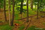
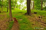
Hike Directions: From the parking area, head south a few hundred feet to find the RED-BLAZED Ramapo-Dunderberg Trail. Follow it into the woods and uphill. In a tenth of a mile, you’ll come across an old railroad tunnel. Continue to the RIGHT of the tunnel and in a few hundred feet, turn RIGHT at an intersection with blue blazes, in order to continue following the RED-BLAZED Ramapo Dunderberg Trail. The climb becomes more steep as you ascend on an old railway bed.
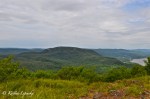
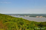
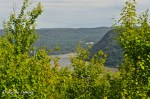
0.66 miles from the intersection with the blue trail, you’ll reach a spur trail going to you’re right. It’s easy to miss, but if you can find it, turn RIGHT here for a few hundred feet for views over the East Hudson and south toward High Tor. Return to the Ramapo-Dunderberg Trail and continue to ascend another 1.66 miles to the summit of Dunderberg Mountain. Continue past the summit, still following the red blazes. In 0.17 miles you’ll reach an intersection with the blue-blazed Cornell Mine Trail, but continue on the red blazes for another 0.16 miles to the summit of Bald Mountain. From here, enjoy sweeping views of West Mountain, Bear Mountain, the Bear Mountain Bridge, Anthony’s Nose, West Point, Fort Montgomery and Fishkill Ridge.
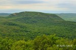
Continue on the RED BLAZES another 0.75 miles to an intersection of red-blazed trails. Continue straight on the Ramapo-Dunderberg Trail (neither going left nor right) and half a mile beyond the intersection of red-blazed trails you’ll reach the summit of the Timp, with views south down the Hudson River. Retrace your steps back to the intersection of red-blazed trails, but this time make a RIGHT onto the red-blazed 1777 Trail. In less than a tenth of mile, turn LEFT on the blue-blazed Timp-Torne Trail. In 1.5 miles you’ll pass another old railway tunnel, as you continue down the mountain for just 0.7 more miles back to the intersection with the Ramapo Dunderberg Trail. Turn RIGHT and downhill for less than a quarter of a mile back to your car.

1 reply »